SATURDAY, 29 JANUARY 2011
Then the monsoon struck. Vegetation sprouted from every crevice in the cracked earth and paths soon became choked with plants. Insects swarmed everywhere. Dry riverbeds became raging torrents.
Suddenly, Everest found himself cut off from his supplies by the river Musi, a tributary of the Kristna. His next goal, the hill of Sarangapalle, was the other side of the Kristna itself. Everest’s elephants, carriers of his prized surveying instruments, refused to cross the swollen river. So Everest and 12 of his trusty men took to the water in a coracle, a small round boat woven from palms and covered in animal hides, which he had found on the river bank. Evening was drawing in, but they pressed on to Sarangapalle, a further 12 miles. By the time they reached the hills the heavens had opened. They spent the night in a raging thunderstorm with no food or tents, their Harris tweeds doing little to keep out the rain. Within a few weeks, the whole of Everest’s party had succumbed to fever. Such was the life of a surveyor in India.
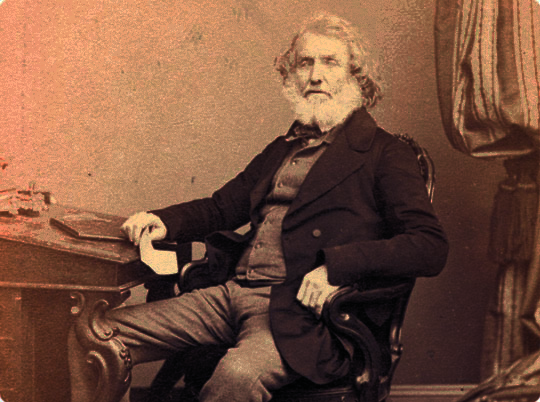
George Everest had taken leadership of The Great Trigonometrical Survey in 1823 upon the death of his successor, Colonel William Lambton, who established it in 1802. It was one of a number of surveys that were set up as part of the colonial enterprise; a way for the British to stamp their authority on Indian territories. It was essential for the British rulers “to have a complete geographical knowledge of the country for their revenue and administrative purposes”. The job of this survey was, quite simply, to determine where places were. Up until this time the only known method for locating a point on the Earth’s surface was to make astronomical observations, which took months if not years to complete. Lambton recognised that surveying by triangulation was the only sensible way to make a map of India.
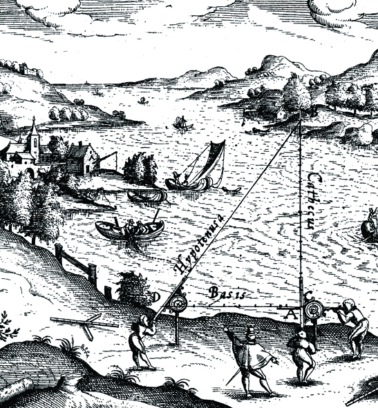
Triangulation involves measuring angles. If the distance between two locations is known and the angle from each of these locations to a third location is measured, then the rest of the distances and angles in the triangle can be calculated using trigonometry. Therefore, the job of a surveyor was to measure the distance along a baseline between two initial locations as accurately as possible and then to keep measuring angles and performing calculations in order to construct a whole network of triangles. However, because of the Earth’s curvature these triangles are actually being measured on the surface of a sphere. In spherical geometry, the angles in a triangle add up to slightly more than 180 degrees. This ‘spherical excess’ had to be taken into account. To make matters worse, the Earth is slightly fatter round the equator than round the poles so it isn’t actually a perfect sphere in the first place. Surveyors had, in other words, to be exceedingly confident in their mathematical ability.
After his ordeal in the Indian jungle, Everest was plagued by fever for the next few years and was forced to return to England in 1825. But Everest used his time in England wisely, spending five years improving his instruments. He liaised with Troughton & Simms instrument makers in London to devise a new, smaller, lighter and cheaper theodolite. He also decided to make use of compensation bars, a pair of iron and brass bars strapped together, for measuring his distances. Since the two metals expand to different extents when heated, the effect of temperature on the length of the bars is compensated for. He also adopted a new surveying strategy. He realised that he didn’t need to cover the whole country with triangles but could instead create a gridiron pattern: an array of north-south and east-west traverses across the country that intersected at right angles.
Finally, in 1830 Everest returned to India. He started by triangulating from Dehra Dun to Sironj, a distance of 400 miles across the plains of northern India. The land was so flat that Everest had to design and construct 50 foot high masonry towers on which to mount his theodolites. Sometimes the air was too hazy to make measurements during the day so Everest had the idea of using powerful lanterns, which were visible from 30 miles away, for surveying by night. With all this new equipment, Everest’s party was now 700 men strong. The entourage included four elephants for the principals to ride on, thirty horses for the military officers and forty-two camels for carrying supplies.

People are unsure whether Everest ever laid eyes on the mountain that bears his name. It was his successor, Andrew Waugh, who extended the triangulation network into the Himalayas and named the mountain after him. Waugh wanted “to perpetuate the memory of that illustrious master of geographical research…Everest.” Unfortunately, Waugh wasn’t aware of the local Tibetan name of Chomolungma; perhaps another mark of the nature of British colonialism. But it is nevertheless fitting that the tallest mountain in the world is at least in part named after one of the giants of surveying.
Today, the Ordnance Survey in the UK employs a combination of aerial photographs and GPS (global positioning satellites) for their map making, meaning it can largely be done at a desk. However, the dedication of 19th century surveyors such as Everest in the face of so many adversities is commendable. Indeed, The Great Trigonometrical Survey of India has, quite appropriately, been described as “one of the most stupendous works in the whole history of science.”
Tim Middleton is a 3rd year undergraduate in the Department of Earth Sciences
