MONDAY, 4 APRIL 2011
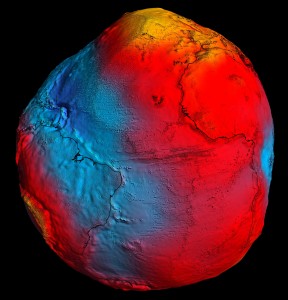
Measurements required to construct the models were taken by the European Space Agency satellite GOCE (Gravity Field and Steady-State Ocean Circulation Explorer), which was launched in 2009. The new dataset is more accurate and has a much higher spatial resolution than any that were previously available. It will allow scientists to make advances in several areas of Earth system science, ranging from improved understanding of ocean circulation and ice dynamics to a greater knowledge of the physical properties and geodynamic processes in the Earth's interior [1].The GOCE mission is one of the most innovative Earth observation missions to date. The satellite carries a state-of-the-art gradiometer which measures Earth's gravity with unrivalled precision. The instrument, which is the first of its kind in space, comprises six accelerometers, each of which can detect accelerations of Earth's gravity to within one part in ten trillion.
The Explorer has now fulfilled its mission goals. However due to the extraordinary quality of the data it has collected and continuing good condition of the satellite the mission has been extended until the end of 2012.
Written by Katie Atkinson

